
|
|
||||
Feature Articles: Alien Abductions, Cattle Mutilations, Conspiracies, Roswell, UFOsInitial Field Report of the Howell Township, Livingston County, Michigan Crop Circle Formation
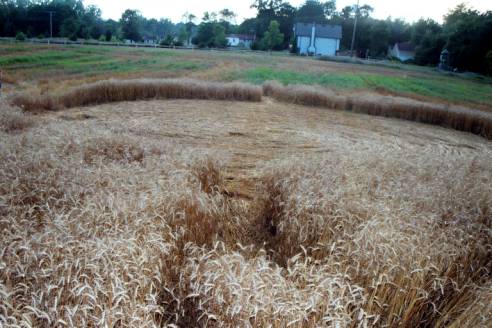
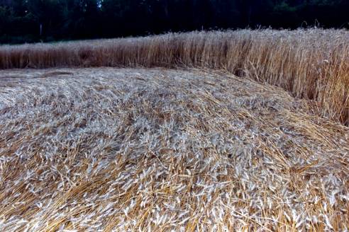
[Ground photo of Howell Township crop circle formation facing West.] Introduction On July 29-31, 2003, a private scientific research team documented physical evidence revealing that the Howell Township, Livingston County, Michigan crop circle formation was not made by hoaxers. The team consisted of Jeffrey Wilson, Todd Lemire, and Dr. Charles Lietzau of Michigan, and Roger Sugden of Indiana. Arriving at the field on July 29, 2002, we discovered and photographed the presence of several anomalies that cannot be duplicated by hoaxers. Account of Discovery Mike Esper, the farmer, on the afternoon of July 24, was harvesting his field at the corner of Mason and Burkhardt roads when he noticed a small, approximately 10’ diameter circle of flattened wheat near the Western edge of his wheat field. He didn’t think very much of it, other than considering it might have been made by some kids, and drove his combine right over the top of it. Soon after, about 100 feet to the East, Mr. Esper spotted a much larger, flattened circle of wheat, and steered his harvester around the circle leaving approximately 10-15 feet of standing wheat bordering the flattened wheat. Mr. Esper was insistent that there were no tracks into either of the circles, and there was no other flattened wheat in the field. Mr. Esper had contracted a third party to spray parts of his field for weeds two times in the previous three weeks, and contacted the sprayer to see if he had noticed the circles. Although the area where the circles were located had not been sprayed, the sprayer said that he hadn’t seen the circles the first time he sprayed, but when he had sprayed the field two weeks later, he had noticed them, but didn’t bother to mention it to Mr. Esper at the time. Therefore, we can only narrow down the time of formation to this two-week window of time from about July 10-24.
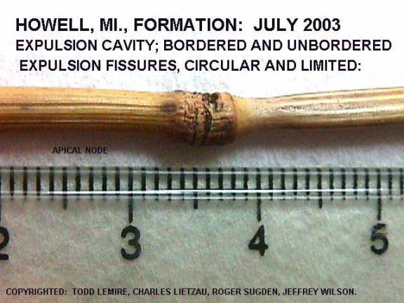
Plant Anomalies Mr. Esper recalled that the spraying company would not come to spray his field unless the moisture content of his wheat plants was less than 35%. Consequently, the wheat was in a very dry state when this formation occurred. Still, as low as the moisture content was, many of the plants inside these circles show the result of the formative energies in the form of massive expulsion cavities (blown node collars), and a slightly different anomaly that we are calling ‘expulsion fissures’. In our previous Kekoskee / Mayville, Wisconsin report we documented the existence of the blown node collars / expulsion cavities which we also found in this formation. However, we also uncovered these ‘expulsion fissures’ that seem to be the result of the flash heating by whatever energy was responsible for this event, but because of the lack of internal moisture, internally ruptured and created these fissures (see photo). Microscopic analysis at a magnification of 30x shows that the upper surface of these expulsion fissures have ruptured horizontally and the edges are pulled back slightly. These expulsion fissures were not found in any of the standing wheat left up around the larger circle, nor in a swath of wheat missed by the combine found 200 feet to the North. [View of one of the many expulsion fissures from the flattened stalks of wheat found inside the formation.] We believe that this is the first time that these ‘expulsion fissures’ have been documented. Blown node collars have never been found in any hoaxed crop circles, nor in any control samples that have ever been studied. There is no known technology that is able to duplicate this blown node collar effect on thousands of plants in these downed areas of crop fields. However, putting stems into a microwave oven, and cooking them for a short time have reproduced this effect. The appearance, then, of these blown node collars is conclusive evidence - in itself - that these circles were not flattened by human-mechanical means, and the appearance of expulsion fissures – a previously undocumented anomaly never reported in standing wheat, wheat flattened by hoaxers, nor in previously reported ‘authentic’ crop circle formations, also adds additional evidence that these circles were not hoaxed.
We also followed the L-NEAT (Levengood Node Elongation Analysis Test) scientific protocol to determine if there was a statistical difference in the measurement of growth nodes of plants inside the circles as compared to the measured length of growth nodes of control plants taken from outside the circles in the standing wheat. This test positively identified the fact that the growth nodes of plants found inside the circles were statistically larger than the growth nodes of control plants measured from outside the circles in the standing wheat. This elongation or enlargement of the growth nodes of these plants cannot be duplicated by any demonstrated hoaxing techniques. This positive result from L-NEAT test, then, independently and conclusively confirms that no human-mechanical means were used in the creation of these crop circles.
Bent growth nodes in the past have been used as a determination of the authenticity of crop circle formations, but that methodology does not always work. Both phototropism and geotropism can cause node bending after crops are flattened, although it has been shown experimentally to take several days for those processes to exhibit a noticeable growth node bending effect. Because we arrived at the formation almost three weeks after it formed, we did not use node bending as a criteria for authenticity. Soil Anomaly and Sampling We collected soil samples from the formation, but we did not find any unusual magnetic anomalies in the field. We are planning to further analyze the soil samples in a lab environment. The crop circle formation is located at approximately 42°36.04m N latitude, and 84°00.04m W longitude. However, we were unable to conclusively obtain an approximate feet-above-sea-level measurement from within the formation. Our attempt resulted in a measurement inside the large circle +858ft above sea level, and a reading of +854 ft above sea level for the smaller circle. The two circles were exactly 135 feet apart. Between the two circles, we took a GPS reading every 20 feet and received elevations of +943-+955 feet above sea level. The area does not change in elevation more than 15 feet across the distance between the circles, so we have an anomaly of the circles appearing to be approximately 100 feet in elevation below the rest of the field.
Considering that our team arrived possibly three weeks after the crop circles formed, we did not expect to find the presence of any residual Electro-Magnetic anomalies. In fact, we did conduct a preliminary Electro-Magnetic field measurement soon after arriving at the location. We took measurements from inside the formation and from outside the formation which showed no elevated measurements of either electric field strength or magnetic field strength. So, due to time constraints, and considering our past experience of not finding high E-M readings more than approximately 10 days after circle formation, we abandoned those tests. At this time, we can only speculate on the cause of the GPS anomaly, which does not appear to be electromagnetic in nature, but caused by something else.
Crop Circle Formation Description and Measurements The Howell, Michigan formation appears at first glance to be a relatively simple design, but in fact turns out to have some unprecedented complexity not seen before in a crop circle formation. All of the media stories and reports so far have reported on two circles: the large circle (what we have named Circle #1) is an ellipse measuring about 48’-52’ in diameter with two straight pathways extending from the circle at opposing directions – one to the E/NE and another to the W/SW. What the previous reports have not mentioned (because it was undiscovered until we found this) is that there are four additional circles underneath the lay of Circle #1!
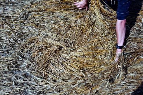
[First of the four circles swirled first before being covered up by the lay of Circle #1.] I noticed the first one as I was pointing out the multiple layers I had seen to Roger Sugden. In pulling back the counter-clockwise lay of Circle #1, I uncovered a 3’ diameter circle, also swirled counter-clockwise exactly 3’ from the outside perimeter. It was also located in the due South position inside Circle #1. I just guessed that there might be more, and that they might be located on the cardinal points. This was exactly the case. We found four smaller circles, one located at each of the cardinal points around Circle #1 that had been swirled down BEFORE the larger 52’ diameter circle had been flattened over the top of them. E/NE Pathway – measurements: 11’ 5” long (Flattened from W/SW to E/NE) by 2’1” wide, and had a slight curve to the NE. W/SW Pathway – measurements: 12’ 11” long (Flattened from E/NE to W/SW) by 2’wide, and had a slight curve to the SW. These pathways were flattened away from the central circle, and were not exactly opposite each other but were ‘offset’ so that the North facing edge of the E/NE pathway is in line with the South facing edge of the W/SW pathway. Circle #1 – measurements: large circle swirled counter-clockwise, with two opposing pathways and four circles swirled underneath; radius’ distances from the center swirl to outside edge measured 23’1” – 28’ 4”
N/S – 48’ 2” diameter NW/SE – 49’ 2” diameter E/W – 51’ 9” diameter NE/SW - 51’ 9” diameter The four circles underneath the Circle #1 lay were all swirled counter-clockwise, and their measurements were:
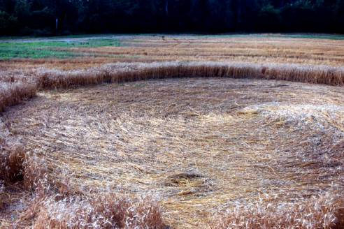
1a. North circle: 3’ diameter; 3’ from perimeter 1b. East circle: 6’ 4” diameter; right to the perimeter edge and pathway edge 1c. South circle: 3’ diameter; 3’ from perimeter 1d. West circle: 4’ 7” diameter; right to the perimeter edge and pathway edge [Photo showing the locations of the four circles underneath Circle #1, and the ‘hourglass’ shading.] Circle #1’s lay of the crop was extremely impressive. The wheat was of the delicate ‘bearded hairs’-type variety, and was undamaged when first found. The lay had a ‘hourglass’ shading effect produced by changes in light reflections from the swirl. There were in several places instances of multiple layering in addition to finding the four circles swirled underneath the main circle’s lay. [Photo showing the ribbons and braiding effect.] There was also a ‘ribboned’ and ‘braiding’ effect towards the outer edge of the circle, while nearest to the center of the circle, the stalks of wheat were woven into a very tight spiral. Circle #2 – measurements: small circle swirled counter-clockwise; radius’ distances from the center swirl to outside edge measured 4’5” – 5’ 11” N/S – 10’ 3” diameter NW/SE – 10’ 4” diameter E/W – 10’ 6” diameter NE/SW - 10’ 5” diameter In an extensive search of the crop circle literature, we believe this is the first time that multiple circles in a formation have appeared, and then a larger circle has been flattened right over the top of the original circles. Additional Circle Added La On July 31, I received another call from Mr. Esper late in the day to tell me he had found another crop circle in the same field as the previously reported formation. Roger Sugden and I had left the field the previous night at about 9:30 pm EDT, and the circle was not there. Mr. Esper called me after finding it about 6:30 pm EDT the next day. It appeared during this ~18 hour time frame. There was no unusual weather during that time period. Knowing that the field had already been harvested, I was curious as to where this circle was located. He told me that this new circle appeared in the standing wheat that he had left up bordering around Circle #1. I arrived at the formation location after dark, and measured the new circle at 6’ 7” in diameter. The circle was swirled counter-clockwise and right to the edge of the harvested wheat. I did not detect any elevated readings with my Geiger counter, and no elevated readings in electric field strength or magnetic field strength. I spent at least a half an hour looking for expulsion cavities in this small circle but I found none. We cannot conclusively make a determination of the authenticity of this additional circle, but we would say it is a probable hoax.
Crop Circle Location Geology and Context Arriving at the field, we noticed a special blue road sign reading “Wellhead Protection Area.” Inquiring as to what this designation meant, it turns out that the field marks the beginning of the boundary of where a specially protected area has been defined to protect the local watershed from certain polluting industries, and where the city of Howell draws its water supply. The field where the crop circle formation appeared has two large wells – one of which helps supply the city with water. Also located about 100’ East of Circle #1 is a drain field that empties into a swamp at the North border of the field. The field itself sits on top of a large aquifer and a layer of sandstone that is being mined by a cement company less than a mile to the West of the field. Between the cement company and the Western border of the field is a branch of the Red Cedar River. Crop circles have been noted to appear near some sort of body of water: a creek, a pond, a drainage ditch, etc, and with this formation, water appears to be in plentiful supply all around – and below- this formation.
Crop Circles have also been known to form in close proximity to power lines, and again this circle site is no exception – less than 15 feet from Circle #2 is power line with a transformer box on it. We also were told that an Indian Mound archaeological site had recently been uncovered in Cedar Lake, Michigan a few miles away, and we are working to confirm the location of this site.
Conclusions Our research team had at this point in our investigation enough conclusive scientific evidence as well as a body of supporting contextual detail to show that the Howell crop circle formation had not been hoaxed by people using mechanical means, and that the evidence uncovered supports the conclusion that this is an authentic formation. There are other anomalies that were detected in this formation, but until our lab studies are concluded, and we are certain of our findings, we will refrain from reporting those at this time. Acknowledgements Our scientific research team would like to thank Mr. and Mrs. Esper for their generous hospitality and cooperation in allowing us to conduct our research. We would also like to thank an unnamed group of young gentlemen who graciously helped us collect plant samples as the daylight was fast disappearing. We hope that by sharing this report with them - and the world - about the crop circle formation in their community, we can build a broader understanding of the causative nature of crop circles worldwide, and set an example for the collaborative study of the phenomenon of crop circle formation.
Jeffrey Wilson, M.S. Charles Lietzau, Ph.D. Todd Lemire, Michigan MUFON Chief Investigator Roger Sugden, Indiana MUFON Assistant State Director August 4, 2003 [All photos are copyright 2003 Roger Sugden, Todd Lemire, Charles Lietzau, and Jeffrey Wilson, and may not be reprinted, republished, or reused without permission.]
Reprinted with permission of the authors. Quotes may be excerpted from this article provided full credit is given to the authors and this web site. |
Alien Abduction Experience and Research
Copyright ©1996 - 2019. All Rights Reserved.
